Wêne:Kurdistan 1998.png

Mezinahiya vê pêşdîtinê: 685 × 600 pîksel. Resolusyonên din: 274 × 240 pîksel | 548 × 480 pîksel | 966 × 846 pîksel.
Dosyeya orjînal (966 × 846 pixel, mezinbûnê data: 57 KB, MIME-typ: image/png)
| Ev pel ji Wikimedia Commonsê ye. Agahdariya li ser rûpela danasîna pelê li jêr tê nîşandan. |
Danasîn
| Danasîn |
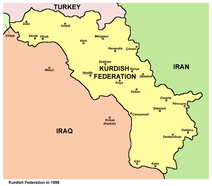
English: Map of Kurdish Federation (Southern Kurdistan) in 1998. |
| Dîrok | |
| Çavkanî | Min çêkir |
| Xwedî | PANONIAN |
Lîsans
I, the copyright holder of this work, hereby publish it under the following license:
| This file is made available under the Creative Commons CC0 1.0 Universal Public Domain Dedication. | |
| The person who associated a work with this deed has dedicated the work to the public domain by waiving all of their rights to the work worldwide under copyright law, including all related and neighboring rights, to the extent allowed by law. You can copy, modify, distribute and perform the work, even for commercial purposes, all without asking permission.
|
References
Created according to these sources:
- http://www.globalsecurity.org/military/world/war/kurdistan-maps.htm
- http://www.globalsecurity.org/military/world/war/images/kurdistan-map-large.gif
- http://www.globalsecurity.org/military/world/war/images/kurdistan-map-ed.gif
- http://pshdar.com/image/sher/heremi-kurdistan.gif
- http://www.zagros.org/images/kurdistan/herem-map.jpg
Dîroka daneyê
Ji bo dîtina guhartoya wê demê bişkoka dîrokê bitikîne.
| Dîrok/Katjimêr | Wêneyê biçûk | Mezinahî | Bikarhêner | Şirove | |
|---|---|---|---|---|---|
| niha | 21:07, 10 tebax 2014 | | 966 x 846 (57 KB) | PANONIAN | more cities |
| 10:25, 14 hezîran 2012 |  | 966 x 846 (45 KB) | PANONIAN | {{Information |Description ={{en|1=Map of Kurdish Federation in 1998.}} |Source ={{own}} |Author =PANONIAN |Date =2012 |Permission = |other_versions = }} |
Bikaranîna pelê
Ev rûpelên li jêr vê dosyeyê bi kar tînin:
Bikaranîna gerdûnî ya pelê
Ev wîkiyên di rêzê de vê pelê bi kar tînin:
- Bikaranîna di ar.wikipedia.org de
- Bikaranîna di arz.wikipedia.org de
- Bikaranîna di ast.wikipedia.org de
- Bikaranîna di bs.wikipedia.org de
- Bikaranîna di ca.wikipedia.org de
- Bikaranîna di cs.wikipedia.org de
- Bikaranîna di da.wikipedia.org de
- Bikaranîna di de.wikipedia.org de
- Bikaranîna di el.wikipedia.org de
- Bikaranîna di en.wikipedia.org de
- Bikaranîna di eo.wikipedia.org de
- Bikaranîna di es.wikipedia.org de
- Bikaranîna di fr.wikipedia.org de
- Bikaranîna di he.wikipedia.org de
- Bikaranîna di hy.wikipedia.org de
- Bikaranîna di it.wikipedia.org de
- Bikaranîna di ja.wikipedia.org de
- Bikaranîna di ko.wikipedia.org de
- Bikaranîna di ms.wikipedia.org de
- Bikaranîna di nl.wikipedia.org de
- Bikaranîna di pl.wikipedia.org de
- Bikaranîna di ru.wikipedia.org de
- Bikaranîna di sh.wikipedia.org de
- Bikaranîna di simple.wikipedia.org de
- Bikaranîna di sr.wikipedia.org de
- Bikaranîna di su.wikipedia.org de
- Bikaranîna di ta.wikipedia.org de
- Bikaranîna di tr.wikipedia.org de
- Bikaranîna di uk.wikipedia.org de
- Bikaranîna di uz.wikipedia.org de